
Imagine giving firefighters a superpower. The ability to see right through thick, choking smoke, track a fire's unpredictable path in real time, and spot hidden dangers before anyone on the ground even knows they're there. That's exactly what drones in firefighting are doing. These unmanned aerial vehicles (UAVs) deliver crucial intelligence that saves lives and completely changes the playbook for managing fires.
A New Perspective on the Fireground
Think of a drone as the ultimate lookout. It gives incident commanders a live, bird's-eye view of a chaotic and dangerous fireground. This elevated perspective is a genuine game-changer, allowing them to deploy crews with pinpoint precision, anticipate where the fire is heading next, and make smarter, faster decisions when every single second counts.
This guide will cut through the technical jargon to show you how this technology is reshaping firefighting. We're moving away from a purely reactive battle and into a proactive, data-driven strategy. It’s all about giving first responders the information they need to work safer and smarter.

Shifting from Reaction to Proactive Strategy
For decades, firefighting has been a ground-level fight against an incredibly unpredictable enemy. Commanders had to piece together a picture of the scene from fragmented reports radioed in by crews, whose own vision was often blocked by smoke and challenging terrain. This inevitably created information gaps, leading to resources being sent to the wrong place or, worse, putting firefighters in harm's way.
Drones close those gaps. They provide a constant stream of reliable, real-time data, allowing for a far more strategic approach. Decisions can now be based on a complete operational picture, not just an educated guess.
By providing a live overhead view of the fire, crew positions, and unseen hazards, drones allow commanders to make proactive decisions. They can deploy teams more effectively and, most importantly, pull them out of harm's way before a situation becomes too dangerous.
Drones fundamentally change how fires are managed by providing a complete, real-time view of the incident. This aerial intelligence helps at every stage of the operation, from the initial response to the final damage assessment. The table below breaks down the key roles drones play.
Key Roles of Drones in Fire Management
| Phase of Operation | Drone Function | Impact on Firefighting Efforts |
|---|---|---|
| Before (Pre-Fire) | Pre-planning & Hazard Mapping: Surveying high-risk areas, identifying access routes, and mapping fuel loads. | Helps create better incident action plans and allows for faster, more effective deployment when a fire does break out. |
| During (Active Fire) | Situational Awareness & Hotspot Detection: Providing live video, thermal imaging, and fire perimeter mapping. | Enhances firefighter safety by spotting hidden dangers. Allows for precise allocation of resources to the most critical areas. |
| After (Post-Fire) | Damage Assessment & Investigation: Creating high-resolution maps and 3D models of the affected area. | Speeds up the recovery process, provides clear evidence for investigators, and helps in planning future mitigation efforts. |
As you can see, the value of drones extends far beyond just putting eyes in the sky during a blaze. They've become an indispensable tool for the entire fire management lifecycle.
The Core Benefits of Aerial Intelligence
The real value of using drones in firefighting boils down to a few key advantages that directly boost safety and efficiency. These benefits don't work in isolation; they combine to create a much safer environment for firefighters and deliver better outcomes for the communities they protect.
Here’s how they make a tangible difference:
- Enhanced Situational Awareness: Drones give commanders a complete picture of the fire scene. They can see its size, how fast it's moving, and where it's headed, which is absolutely vital for planning containment strategies.
- Improved Firefighter Safety: A drone with a thermal camera can spot hidden hotspots through smoke or identify structures on the verge of collapse. It’s an early warning system that helps crews avoid taking unnecessary risks.
- Efficient Resource Allocation: When you can see the whole picture, you can send your people and equipment—like water tankers or ground crews—to the places where they'll have the biggest impact. No more guesswork.
- Post-Fire Assessment: Long after the flames are extinguished, drones are invaluable for mapping the aftermath. They can quickly generate high-resolution maps and 3D models used for fire investigation, insurance claims, and planning recovery efforts.
The Technology Powering Aerial Response
What's the difference between a specialised firefighting drone and the kind you see at the local park? It comes down to the professional-grade toolkit it carries. These aren't just flying cameras; they're rugged, purpose-built machines designed to work flawlessly in some of the most hostile environments imaginable.
Think of it like a Swiss Army knife for the sky. Each tool, or sensor, gives incident commanders a critical advantage they simply wouldn't have otherwise. This specialised gear is what turns a regular drone into a non-negotiable asset for modern firefighting.

Seeing Through Smoke with Thermal Imaging
If there's one piece of tech that defines a firefighting drone, it’s the thermal camera. This sensor doesn’t see light like our eyes do. Instead, it detects heat, painting a picture of the world based on temperature.
For firefighters, this is practically a superpower. A thermal camera can slice straight through thick smoke, darkness, and even dense bushland to reveal the true heart of a fire. It pinpoints the exact location of the fire front, finds hidden hotspots smouldering away, and can even spot the heat signature of a trapped person or animal that would be completely invisible to the naked eye.
This technology lets crews attack the fire where it’s most intense, rather than wasting precious water on cooler, less active zones. It provides a real-time, colour-coded heat map, turning what was once guesswork into a precise, surgical operation.
This ability is a game-changer for everything from structure fires to sprawling bushfires, offering total clarity when visibility on the ground is zero.
Essential Payloads for Fireground Intelligence
While thermal imaging is the star of the show, other sensors work together to build a complete operational picture for the command post.
- High-Resolution Optical Cameras: These are powerful zoom cameras that provide crystal-clear visual information from a safe distance. A pilot can inspect the structural integrity of a burning roof or identify specific hazards on the ground without putting anyone in harm's way.
- Gas Detectors and Air Quality Sensors: During industrial or urban fires, drones can carry sensors to detect toxic gases like carbon monoxide or other chemical threats. This creates an invisible safety net, warning commanders about hazardous air quality before they send crews into a dangerous environment.
- Lidar Sensors: Light Detection and Ranging (Lidar) uses laser pulses to create incredibly detailed 3D maps of the terrain. After a fire, these maps are invaluable for accurate damage assessment, analysing soil erosion risk, and planning rehabilitation work.
The ability to swap these payloads makes drones in firefighting incredibly versatile. The right tool can be chosen for the specific mission, whether that’s initial reconnaissance, active monitoring, or post-incident analysis. Making sense of all this data is where specialised software for UAV comes in, turning raw information into actionable intelligence for commanders.
Built to Withstand the Heat
Of course, none of this advanced tech would matter if the drone couldn't handle the brutal conditions of a fireground. Firefighting drones are engineered from the ground up for durability.
They have rugged, often heat-resistant airframes that can cope with high ambient temperatures and the violent air currents a large fire creates. They’re also fitted with powerful motors and long-endurance batteries, ensuring they can stay airborne for extended periods to provide continuous surveillance when it counts. This robust design makes sure the drone is a reliable tool, not a liability.
The demand for this kind of technology is growing fast. Firefighting drones are a rapidly expanding part of Australia’s emergency response market, especially as fire seasons intensify. Globally, the market is projected to jump from $1.33 billion to $2.05 billion by 2029, a clear sign of just how much we're coming to rely on this life-saving tech.
How Drones Are Used on the Fireground
Getting a drone in the air during an emergency isn't as simple as just hitting the 'on' button and taking off. It's a carefully coordinated process, where every step is designed to deliver crucial information without adding any extra risk to the situation. The entire workflow, from the moment a drone is requested to the final data analysis, shows just how deeply these tools are becoming part of modern firefighting strategy.
It all starts with the Incident Commander on the ground. When they realise they have a blind spot—a gap in what they can see and know—they'll call for aerial intelligence. This isn't just a whim; it's a strategic move to get a perspective that ground crews simply can't access. From there, a certified and experienced drone pilot gets to work.
Pre-Flight Checks and Safe Deployment
Before a drone even sees the sky, the pilot runs through an exhaustive pre-flight checklist. This is a non-negotiable step. It involves checking the drone's physical condition, making sure batteries are full, all the sensor connections are solid, and it has a strong GPS lock.
At the same time, the pilot scans the area to find a safe spot for launch and landing, well clear of any people or obstacles. Safety is everything.
Once the green light is given, the drone is launched from this safe zone, often a good distance from the immediate danger. The pilot is in constant radio contact with the Incident Commander and any other aircraft in the sky, like helicopters or planes, making sure everyone knows where the drone is and what it's doing. This clear communication is what makes the whole operation work safely and effectively.
Live Data Stream to the Command Post
Once it's airborne, the drone gets to its most important job: sending a live feed of high-definition video and thermal imagery straight back to the command post. Think of it as an instant, real-time bird's-eye view of the entire fireground, giving decision-makers the information they need, as it happens.

This visual shows how a drone creates a fast feedback loop, turning what it sees in the air into intelligence that crews can act on immediately.
With this overhead view, commanders can:
- Track Fire Progression: See exactly where the fire front is, how fast it’s moving, and where it’s heading next.
- Monitor Crew Locations: Keep a watchful eye on firefighting crews, confirming their positions and making sure they're safe, especially in tricky terrain.
- Identify Escape Routes: Spot safe ways out for crews in high-risk zones or warn them if the fire’s behaviour suddenly changes and threatens to cut them off.
This kind of aerial support isn't just for fires, either. The use of specialised drones for rescue is also on the rise, helping to find people lost in hard-to-reach places and saving lives far beyond the fireline.
To really understand how this all comes together in the field, here's a simple breakdown of a drone deployment during a bushfire.
Drone Deployment Workflow in a Bushfire Scenario
| Step | Action | Objective |
|---|---|---|
| 1. Request | Incident Commander requests aerial support for a specific task (e.g., spot fire detection). | To fill a critical information gap that ground crews cannot see. |
| 2. Briefing | Drone pilot receives a mission brief, including objectives, flight area, and known hazards. | To ensure the pilot understands the mission and safety parameters. |
| 3. Deployment | Pilot travels to a designated safe launch zone, away from active operations and hazards. | To establish a secure operational base for the drone flight. |
| 4. Pre-Flight | Pilot conducts full pre-flight checks on the drone, payload, and software. | To guarantee the equipment is safe and fully functional before launch. |
| 5. Launch | Drone is launched and flies to the target area, maintaining communication with command. | To position the drone to begin collecting and streaming data. |
| 6. Data Stream | Pilot operates the drone, streaming live thermal and visual video back to the command post. | To provide real-time situational awareness to decision-makers. |
| 7. Mission End | Once the objective is met or batteries are low, the drone returns to the launch zone and lands. | To safely conclude the aerial operation and secure the drone. |
| 8. Data Offload | Pilot downloads all high-resolution images and video for post-incident analysis. | To preserve the collected data for mapping, investigation, and reporting. |
This table shows the logical sequence of events, ensuring every flight is purposeful, safe, and delivers valuable intelligence.
Post-Flight Analysis and Recovery Planning
A drone’s job isn’t over when it touches down. The mountain of data it gathers during a flight is often just as crucial after the fire has been put out. All that high-resolution imagery and sensor data is downloaded and stitched together to create incredibly detailed and accurate maps of the area.
The data gathered during a flight is transformed from raw imagery into powerful analytical tools. These detailed 3D maps and orthomosaics provide an objective, measurable record of the fire's impact, which is essential for effective recovery.
This post-incident intelligence is used in several ways. Fire investigators can use the maps to pinpoint where a fire started and figure out the cause. Insurance assessors and property owners rely on the data for clear damage assessments. And for environmental agencies, it’s a vital tool for planning land rehabilitation and preventing future problems like soil erosion. It just goes to show that a drone's value is felt long after the smoke has cleared.
Real-World Impact in Australian Bushfires
The true worth of any technology isn't measured on a spec sheet. It's proven on the ground, when everything is on the line. Across Australia's harsh and unpredictable fire seasons, drones have graduated from a promising idea to a vital, battle-tested tool. They're fundamentally changing how our agencies tackle the unique challenges of bushfires, giving them a strategic edge right where it's needed most.
This shift is most powerful in the move away from simply reacting to fires towards actively preventing them. Drones have become the ultimate sentinels, patrolling vast, remote landscapes to hunt down threats before they have a chance to explode into uncontrollable infernos.
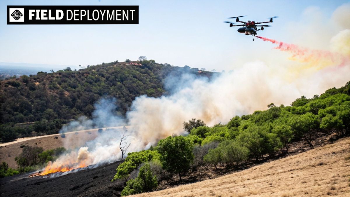
Hunting for Sleeper Fires After Lightning Storms
Picture this: a massive lightning storm rolls across the remote bush overnight. It might leave behind dozens of small, smouldering strikes in trees or deep in root systems. We call these ‘sleeper’ fires—quiet, hidden threats that can sit dormant for hours, even days, before the afternoon heat and wind whip them into a raging blaze.
By morning, these embers are almost impossible to spot from the ground. Even a helicopter crew might miss them. This is where thermal drones in firefighting become absolutely indispensable.
At first light, teams can send up drones to systematically scan thousands of hectares of bush. The thermal cameras cut right through the cool morning air, picking up the tiny heat signatures that ground crews would never find. This gives firefighters precise GPS coordinates for each potential fire, creating a clear, actionable map of emerging threats.
By finding these sleeper fires while they're small and manageable, fire agencies can send in ground crews or water-bombing aircraft with surgical precision. It's a proactive approach that snuffs out threats before they ever make the news, saving critical resources, property, and entire ecosystems.
This early detection completely flips the script, letting agencies get ahead of the game.
A Strategic Shift to Early Intervention
This kind of proactive surveillance isn’t just a new tactic; it’s a major strategic shift. Instead of waiting for a 000 call to react to an established fire, drones empower agencies to actively hunt down and neutralise risks before they grow.
This is especially critical in Australia, where drones are transforming firefighting. They’re often deployed to spot fires in their infancy, especially at night when lightning strikes cause small ignitions in remote areas. Using small drones to keep an eye on smouldering tree roots or smoke plumes gives fire crews the exact data they need by dawn. This enables a rapid attack before a fire has any chance to escalate. You can discover more about these applications in this Australian Geographic article.
This capability isn't just about being more efficient; it's about breaking the cycle of catastrophic fire events. The benefits are clear:
- Increased Safety: Crews are sent to small, manageable ignitions instead of having to confront massive, unpredictable fire fronts.
- Resource Optimisation: It takes far fewer resources to put out a small fire, freeing up people and equipment for other priorities.
- Reduced Environmental Impact: Containing fires early prevents the widespread destruction of habitats and minimises smoke pollution.
- Community Protection: The risk to rural properties and communities is massively reduced by stopping fires at their source.
Gaining Clarity in Active Firefighting Scenarios
Beyond prevention, drones give incident commanders an incredible level of clarity during an active fire. In the chaos of a large bushfire, a live drone feed can cut through all the smoke and confusion.
For instance, a drone can map the fire perimeter with pinpoint accuracy, showing crews exactly where the fire is and, more importantly, where it’s heading. This real-time intelligence helps commanders make smarter, faster decisions about where to build containment lines, position resources, and issue timely evacuation warnings.
Imagine a crew working to protect a property, completely unaware that a sudden wind change is pushing a spot fire around to their flank. A drone operator, watching the thermal feed from a safe distance, can spot this new danger immediately. They can radio a warning, giving the crew vital minutes to reposition to safety. That's how drones save lives.
Navigating Safety and Aviation Regulations
Flying a drone into the airspace above a wildfire is serious business. It’s a crowded, chaotic, and high-stakes environment where a single mistake can have devastating consequences. You’ve got helicopters, air tankers, and ground crews all working in a coordinated dance, and adding a drone into that mix requires incredibly strict rules.
That’s why solid safety protocols and a deep respect for aviation regulations are the absolute foundation of any drone program in emergency services. The goal is simple: get life-saving intel from the drone without adding a single ounce of new risk to the operation.
Think of the airspace over a fire as a busy, multi-lane highway in the sky, but with no traffic lights. Every aircraft, from a massive water-bombing plane to a small eye-in-the-sky drone, has to know exactly where everyone else is to prevent a disaster.
Deconflicting Crowded Airspace
Keeping all these aerial assets from running into each other is a process called deconfliction. It’s not optional; it’s essential. A drone pilot must be in constant radio contact with the Air Attack Supervisor, who is essentially the air traffic controller for the entire incident.
This communication ensures the drone stays in its assigned box—a specific zone and altitude—well away from any manned aircraft. Without that constant chat and sticking rigidly to the flight plan, a drone goes from being a helpful tool to a serious hazard in seconds.
The core principle of aerial firefighting safety is simple: everyone knows their lane. Drones are carefully integrated into this system, not flown on a whim. This disciplined approach is what allows them to gather critical data without getting in the way of traditional air support.
This is exactly why you can't just be a hobbyist and fly a drone over a fire. Only highly trained and certified professionals get that job.
Rigorous Training and Certification
Here in Australia, the Civil Aviation Safety Authority (CASA) sets a very high bar for emergency service drone pilots. This isn’t a weekend course; it’s a professional qualification that demands deep technical knowledge and an understanding of complex procedures.
At a minimum, pilots need a Remote Pilot Licence (RePL) and usually an Aeronautical Radio Operator Certificate (AROC) to legally talk to other aircraft. But it goes much further than that. Their specialised training covers:
- Emergency Procedures: What do you do if the drone fails, you lose signal, or the weather turns nasty? They have to know how to handle it safely.
- Airspace Management: Learning to read and operate within complex, temporary airspace restrictions that pop up around major incidents.
- Incident Command Integration: Figuring out how to slot into the existing command structure and provide firefighters with the information they actually need.
This level of training gives pilots the technical chops and the situational awareness to perform under immense pressure. A solid grasp of flight principles is a must-have, which is why ongoing education around topics like drone collision avoidance is so critical for building real expertise.
Why Unauthorised Drones Are a Major Threat
The strict rules for official drones really put the danger of unauthorised drones into perspective. The moment a private drone is spotted near a fire, every single firefighting aircraft—from helicopters to air tankers—is grounded. Period.
That means critical water-bombing runs stop, and the firefighters on the ground are left exposed and at much greater risk. The message from every fire agency is blunt and clear: If you fly, we can’t. Following these rules isn't just about ticking a box; it’s about protecting the lives of our first responders and the communities they’re fighting to save.
The Future of Automated Aerial Firefighting
The technology behind drones in firefighting is moving at a breakneck speed. It’s painting a pretty clear picture of a future where firefighting is smarter, safer, and far more automated. We're well past the point of drones being just a fancy pair of binoculars in the sky; we're now entering an era where they act as intelligent partners on the fireground. The next wave of innovation is all about blending seasoned human expertise with machine efficiency.
It’s not just about a single drone anymore. The real game-changer is the idea of a coordinated team of drones working together.
The Rise of Autonomous Systems
The next big leap is all about taking the pilot's hands off the controls for routine tasks, allowing drones to handle complex jobs on their own. This isn't about replacing pilots. It’s about freeing them up to think strategically, letting one person manage a whole fleet of drones carrying out different missions at the same time.
Three key developments are really pushing this forward:
- Autonomous Drone Swarms: Picture a group of drones operating like a well-drilled team. These swarms could be sent out to map a massive fire perimeter in minutes—a job that would take a single drone ages. They talk to each other, divvy up the area, and get the job done with incredible speed and efficiency.
- Predictive AI Algorithms: Soon, drones won’t just show us where the fire is now; they’ll help predict where it’s going next. By feeding real-time data into powerful AI models, these systems can analyse the terrain, weather, and fuel loads to forecast a fire's path. This gives commanders a massive head start on planning their attack.
- Direct Fire Suppression Drones: We’re also seeing bigger, more powerful drones being developed that can carry and drop water or retardant. They won't replace the big air tankers, but they’re perfect for surgical strikes on spot fires or for building containment lines in places that are just too risky for ground crews or helicopters.
Looking ahead, you can see a future where firefighters and intelligent drones are a tightly integrated team. The autonomous systems will handle the immense task of data collection and analysis at a scale humans just can't match.
A Skyrocketing Role in Emergency Services
This technological shift is happening just as the use of drones by emergency services is set to explode. Here in Australia, the growth is going to be massive. Last year, there were about 1.5 million drone flights across the country. That number is predicted to jump to over 60 million by 2043.
Of those, emergency services are expected to be responsible for more than 400,000 flights every year. You can read the full forecast on drone flight growth from Airservices Australia.
This huge increase shows just how much we’re coming to rely on drones to get us critical information safely and quickly. As the technology gets even better, we'll see more advanced applications become standard practice, cementing the role of automated aerial systems as a non-negotiable part of modern firefighting.
Got Questions? We've Got Answers
As drones become a more common sight on the fireground, it's natural to have questions about how they work and where they fit in. Let's tackle some of the most common ones we hear from emergency service professionals.
Will Drones Replace Firefighting Helicopters?
Not at all. Think of drones as the scouts and helicopters as the heavy lifters – they're part of the same team, but with very different jobs. Drones are brilliant for getting a close-up look, especially in thick smoke or at night when it’s far too risky for a manned aircraft.
They feed real-time intelligence to the incident controller on the ground. Meanwhile, helicopters and fixed-wing planes will always be needed for their core mission: dropping huge amounts of water and retardant. The two work together as part of a smart, coordinated air strategy.
Who Actually Flies These Drones for Fire Services?
You can't just hand the controls to anyone. In Australia, firefighting drones are flown by specially trained firefighters and other emergency personnel who've earned their stripes with the Civil Aviation Safety Authority (CASA).
This isn't a weekend course. It involves getting a proper Remote Pilot Licence (RePL) and then undergoing further training focused entirely on emergency scenarios. The goal is to ensure they can operate safely in very crowded, dynamic airspace and translate what the drone sees into actionable intelligence for the command team.
At the end of the day, the single biggest win from using drones is better situational awareness. It’s what keeps our firefighters safe. Getting a live bird's-eye view of the fire, crew positions, and hidden dangers means commanders can make smarter decisions and pull their teams back before a bad situation gets worse.
Can Any Off-the-Shelf Drone Be Used for Fighting Fires?
Absolutely not. The drones you see in emergency services are purpose-built, professional tools designed to survive in extreme conditions. They're a world away from the hobbyist drone you might find in a retail shop. These are rugged machines, often with heat-resistant components.
They also come equipped with features that are non-negotiable on the fireground:
- Long-endurance batteries that keep them in the air for an entire operational period.
- Encrypted data links to guarantee a clear, secure video feed without interference.
- Specialised payloads, like high-resolution thermal cameras and powerful zoom lenses.
These aren't nice-to-haves; they're essential for reliability when property and lives are at stake.
So, What's the Main Benefit of Using Drones?
When you boil it all down, the number one advantage is a massive leap forward in firefighter safety. Drones deliver incredible situational awareness, giving incident commanders a real-time overhead view of the entire scene.
This perspective lets them see exactly how a fire is behaving, keep track of where every crew is, and spot hidden dangers like a collapsing roof or a spot fire flaring up behind their lines. Armed with that knowledge, they can put their teams in the most effective positions and, crucially, get them out of harm's way before it’s too late.
At Innoflight International, we specialise in providing tough, reliable drone solutions for critical sectors like emergency management. Our platforms are built for rapid deployment and high-precision data gathering when conditions are at their worst. To see how our drone technology can support your operational capabilities, we invite you to explore our solutions.