
When we talk about spatial resolution, what we're really asking is: "How much detail can we actually see?" Think of it as the difference between a blurry, out-of-focus photo and a stunningly sharp, high-definition one. It's the measure of the smallest object a sensor can pick out on the ground.
Seeing the World One Pixel at a Time

Every digital image, whether from your phone or a satellite, is essentially a grid of tiny squares called pixels. Each pixel captures a single colour, and together, they form the complete picture. Spatial resolution is all about the real-world size that one of these pixels represents.
Is your aerial survey just seeing a large green patch, or can it pick out individual trees? That’s spatial resolution at work.
For anyone in surveying, construction, agriculture, or environmental management, this isn't just a technical detail—it's everything. It's what makes a map genuinely useful. This whole field of collecting and making sense of geographic data is a huge part of modern mapping. If you're curious about how this information is applied, you can dig deeper in our guide on https://evolutionflight.com/what-is-geomatics/.
From Blurry Blobs to Sharp Details
The difference that resolution makes is staggering, especially when you look at how far the technology has come. The first GOES weather satellites back in the 1970s had a resolution of about 1 kilometre. At the time, this was incredible, but it could only really show massive weather systems. Today, we can see things in centimetres.
"The MAPS dataset was instrumental to this study… it was the only phenological event that could be estimated at a precise spatial resolution."
This quote drives the point home. Pinpoint-accurate, high-resolution data allows researchers to see patterns and draw conclusions that would be completely invisible otherwise. It gives us the power to monitor our environment with incredible precision.
A great example comes from right here in Australia. Researchers used satellite data with a 30-metre resolution to map changes in land cover across the entire continent over three decades. By analysing nearly 300,000 satellite images, they achieved around 93% accuracy, providing critical insights for national environmental policy.
To give you a clearer picture of what these resolution levels mean in practice, here's a quick breakdown.
Quick Guide to Spatial Resolution Levels
| Resolution Level | Typical Pixel Size | What You Can See | Common Application |
|---|---|---|---|
| High | < 1 metre | Individual trees, vehicles, buildings, road markings | Urban planning, infrastructure inspection, precision agriculture |
| Medium | 1 – 30 metres | Large fields, forest stands, major roads, coastlines | Regional land-use mapping, deforestation monitoring |
| Low | > 30 metres | Large-scale weather patterns, major geological features | Global climate modelling, large-scale oceanography |
This table helps illustrate why choosing the right resolution is crucial; you wouldn't use global weather data to inspect a pipeline, and you wouldn't use a high-res drone map to track a cyclone.
The idea of using tiny building blocks to create a clear, detailed picture isn't just for mapping our planet. While our work focuses on sensing the physical world, the same principle applies to creating digital experiences. When building a website or app, a top UX UI design agency also uses pixels to build a clear and functional design. In the end, whether for a map or a mobile screen, resolution is all about turning raw data into real clarity.
How We Measure Detail From the Sky
To really get a handle on spatial resolution, you need to know how we actually measure it in the field. The two main tools we use for aerial mapping—drone photography (photogrammetry) and LiDAR—have slightly different ways of doing things. But the end goal is always the same: putting a number on the level of detail we’re capturing.
Ground Sample Distance in Drone Photography
When we're using drone photography, our go-to metric is Ground Sample Distance (GSD). It sounds technical, but it’s a simple idea: GSD is the real-world size that one single pixel in your photo represents on the ground.
So, if your survey has a GSD of 5 centimetres, it means every pixel in your final map is a snapshot of a 5cm by 5cm square of earth. It’s that straightforward.
This infographic gives a great visual of how a drone's flight path and altitude translate directly into the detail you can measure.
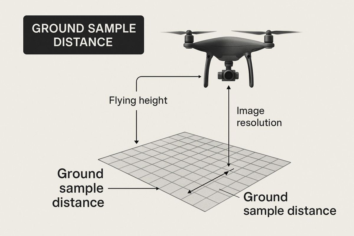
As you can see, the drone's height above the ground is a major factor in determining the GSD, and therefore, the overall resolution of your map.
What Controls Your GSD?
The good news is that you're in the driver's seat when it comes to GSD. It really boils down to two key factors you can adjust:
- Flight Altitude: Fly higher, and each pixel covers more ground. This gives you a larger GSD and lower resolution. Fly closer to the ground, and you shrink that pixel size for a smaller GSD and much higher resolution.
- Camera and Lens: The quality of your gear matters. The camera's sensor resolution (how many megapixels it has) and the focal length of its lens are huge. A top-tier sensor will capture more fine detail, even from the same altitude.
Think of it this way: getting a super-detailed GSD of 2 cm means flying much lower and slower than you would for a broader overview with a 10 cm GSD.
Measuring Detail with LiDAR: It's All About Point Density
When we switch over to LiDAR, we leave pixels behind. Instead, we talk about point density. This is simply the number of laser measurement points we capture for every square metre on the ground, often written as pts/m².
Photogrammetry uses pixels to create a continuous surface, almost like a digital fabric draped over the landscape. LiDAR, on the other hand, builds its 3D model from millions of individual laser points. A higher point density means more of these points are crammed into each square metre, giving you a far more detailed and accurate digital twin of the environment.
A low-density scan, maybe 5-10 pts/m², is perfect for mapping the general rise and fall of the land. But if you need to inspect something with fine detail, like individual power lines, you'll want a much higher density scan—sometimes over 100 pts/m².
Just like with GSD, you control point density by adjusting your flight altitude, speed, and the specific settings of the LiDAR sensor. Getting to know what a LiDAR UAV drone is capable of is the first step in planning a survey that delivers the right results.
Once you master GSD and point density, you gain incredible control over the quality of your aerial data. You can make sure it's not just good data, but the right data for your project's needs.
The Sweet Spot: Balancing Detail Against Data Overload
It’s easy to think that the highest possible spatial resolution is the ultimate prize for any mapping project. I mean, more detail is always better, isn't it? Well, not quite. While chasing that ultra-fine detail gives you incredible clarity, it comes with some serious trade-offs that can throw your project's timeline, budget, and even its feasibility right out the window.
Imagine you're painting a masterpiece. For the tiny, intricate details of a portrait, you’d grab a fine-tipped brush. It gives you precision and control. But what if your job was to paint an entire house? Using that same tiny brush would be a nightmare—slow, frustrating, and wildly inefficient. You’d need a big roller to cover large areas quickly, even if it means sacrificing those minuscule details.
That's the exact dilemma we face with spatial resolution. It’s all about finding that perfect balance between the level of detail you actually need and the resources you have to get the job done.
The True Cost of High Resolution
Pushing for a very low Ground Sample Distance (GSD), say around 1-2 centimetres, means you have to fly the drone much lower and slower. This has a direct knock-on effect.
- More Time on Site: Your flight times stretch out significantly to cover the same patch of ground. A job that could have been done in a day might suddenly become a multi-day mission.
- Higher Project Costs: More time in the field means higher labour costs, more battery swaps, and just generally more operational overhead.
- Massive Data Files: The amount of data you collect balloons. A single project can easily rack up terabytes of information.
And these huge datasets aren't just a storage problem. They require some serious computing muscle—we're talking powerful, expensive machines and specialised software. A dataset that takes a few hours to process at a moderate resolution could tie up your computer for days at an ultra-high resolution, creating a major bottleneck in your workflow.
Finding Your Project's Goldilocks Zone
Of course, going to the other extreme is just as bad. A coarse GSD of 20 centimetres might be quick to fly and a breeze to process, but you could completely miss the very thing you were looking for, like small cracks in a bridge or the first signs of stress in a crop.
The real goal isn't to chase the highest resolution you can get. It's about choosing the most appropriate resolution for the job at hand. This way, you capture all the detail you need without burning through time, money, and processing power on data that won't add value.
This trade-off has been a central part of remote sensing from the very beginning. For decades, satellite imagery has been the backbone of large-scale land monitoring across Australia. Programs like Landsat gave us images with a 30-metre resolution, which was perfectly practical for mapping an entire continent. On the other hand, traditional aerial photography could deliver much finer detail, sometimes down to 25 centimetres, but only for smaller, specific areas. It’s always been this dance between detail and practicality. If you're curious, you can explore more about historical satellite imagery to see just how this balance has played out over the years.
How Resolution Impacts Real-World Accuracy

This is where the theory hits the dirt. The spatial resolution you choose can be the difference between a successful project and a costly failure. It directly controls how reliable your maps are and how accurate your measurements will be. Think of it as the difference between just seeing a building and being able to spot individual cracks in its foundation.
Bad data leads to expensive mistakes. Imagine you’re calculating stockpile volumes on a mining site. If your resolution is too low, the edges of the pile will be fuzzy and hard to define. This can throw off your volume estimates by thousands of dollars. The same goes for construction, where accurate cut-and-fill calculations hinge on a highly detailed terrain model.
From Vague Outlines to Actionable Insights
High-resolution data gives you the ground truth you need to make critical decisions. It turns a simple aerial photo into a powerful analytical tool, letting you move from just looking at something to accurately measuring it.
- In Agriculture: You go from seeing a "stressed area" in a field to pinpointing the exact rows of crops hit by pests or a broken irrigator.
- In Infrastructure: Instead of just confirming a bridge is still there, you can zoom in to monitor for subtle signs of wear and tear over time.
- In Environmental Monitoring: You can measure the precise area of coastal erosion, rather than just noting that "some land was lost."
This level of detail is crucial for maintaining centimetre-level accuracy on large projects. Understanding what RTK GPS is and how it works with high-resolution imagery is essential for getting survey-grade results you can truly trust.
High spatial resolution isn't about making pretty pictures. It’s about pulling reliable, measurable data from those pictures so you can act with confidence. It ensures your digital models are not just detailed, but genuinely dependable.
The demand for more detail is growing across every industry. For instance, the development of high-resolution spatial datasets in Australia has taken a huge leap forward, allowing for much more precise mapping. Spatial Services, the NSW government’s mapping agency, now provides statewide satellite imagery at a 1.5-metre resolution. That’s a massive improvement over the old 30-metre resolution from Landsat imagery, allowing planners to see individual buildings and roads with incredible clarity. You can discover more about how this imagery is being used on the official NSW Government site.
The Right Detail for the Right Job
Ultimately, it all comes down to picking the right tool for the job. To see how different levels of detail affect real-world outcomes, just look at its role in things like geospatial analysis in real estate, where property values can be influenced by identifying features like swimming pools or solar panels.
Choosing a resolution that’s too coarse for your task is like trying to perform surgery with a butter knife. The tool just isn’t precise enough, and the results will be unreliable. But with the right resolution, you can be sure that every measurement, calculation, and decision is built on a solid foundation of accurate, trustworthy data.
Choosing the Right Resolution for Your Project
So, we've unpacked what spatial resolution is, how it’s measured, and the trade-offs you have to make. Now it's time to put that knowledge to work. Think of it less as a technical spec and more as a powerful tool that helps you make smart decisions on the ground.
Choosing the right resolution isn’t about chasing the highest number or the most detailed image. It's about a strategic match between the data you collect and what you actually need to accomplish. To get this right, you need to ask a few simple but crucial questions before you even think about putting a drone in the air.
Key Questions to Guide Your Decision
Before you start drawing up flight plans, take a step back. A quick mental checklist can save you from common headaches, like collecting data that’s completely useless or, just as bad, paying a fortune for detail you don't even need.
Start here:
- What’s the smallest thing I absolutely must see? This is the big one. Are you trying to measure the general shape of a stockpile, or do you need to spot tiny cracks in a concrete pillar? The answer to this question gives you your minimum required Ground Sample Distance (GSD).
- What are my real-world time and budget constraints? Higher resolution costs more. It means more time flying and more hours spent processing, which all add up. You have to be realistic about what your project can actually afford.
- Can my computer even handle this? A super high-resolution survey can spit out massive files—we’re talking terabytes of data. Do you have the processing power and the right software to manage that, or will you create a massive bottleneck for your team?
Answering these questions honestly puts you in the driver's seat. You’ll be able to choose a resolution that’s genuinely fit for purpose.
Choosing the right resolution isn't a technical exercise; it's a strategic one. It ensures that every pixel you capture serves a clear purpose, directly contributing to the accuracy and reliability of your final project outcomes.
This approach is your best defence against collecting data that's too coarse to be useful, or drowning in data so fine it just bogs you down.
Matching Resolution to the Job
Different jobs demand different levels of detail. A surveyor mapping a large mine site has completely different needs from an engineer inspecting a bridge. To make this more concrete, let's look at a few real-world scenarios and the kind of resolution that works best for them.
The following table is a handy guide that links common tasks with the spatial resolution you’d typically need to get the job done right.
Recommended Spatial Resolution for Different Applications
| Industry Application | Task | Recommended GSD | Why This Resolution Is Needed |
|---|---|---|---|
| Construction | Earthworks volume calculation | 3-5 cm | You need sharp, well-defined edges on stockpiles and clear terrain breaks for an accurate cut-and-fill analysis. |
| Mining | Pit and haul road survey | 5-10 cm | This gives you a good balance between covering a huge area and still having enough detail to track changes and keep an eye on safety. |
| Infrastructure | Bridge or building inspection | 1-2 cm | It’s all about spotting the small stuff. This level of detail is essential for identifying critical issues like stress fractures, corrosion, or a loose bolt. |
| Agriculture | Crop health monitoring | 5-15 cm | You can easily spot patterns of plant stress or irrigation problems across a large field without needing to see every single leaf. |
As you can see, the "best" resolution is always relative to the task. If you start with your end goal in mind, you can work your way back to the perfect GSD. This ensures the data you collect is not only precise but also practical and worth the investment.
Got a Few More Questions?
Let's wrap up by tackling some of the most common questions we hear about spatial resolution. These quick answers should help cement what we've covered and clear up any final thoughts.
What’s the Difference Between Spatial and Spectral Resolution?
It's a great question, and the distinction is crucial. Think of it like a digital photo.
Spatial resolution is all about the level of detail you can see—how sharp and clear the image is. It's about the size of the pixels and being able to spot small objects on the ground.
Spectral resolution, on the other hand, is about the richness of the colour information within each pixel. It’s the sensor's ability to see beyond just red, green, and blue, and capture different bands of light, like near-infrared. High spectral resolution is what allows an agronomist to spot subtle signs of crop stress that are invisible to the naked eye.
So, one is about detail, the other is about colour depth.
Why Isn’t Higher Spatial Resolution Always Better?
It seems counterintuitive, right? More detail should always be a good thing. But in the real world of UAS mapping, chasing the absolute highest resolution can cause more problems than it solves.
To get that ultra-fine detail, you have to fly lower and slower. This means longer flight times, more battery swaps, and higher operational costs. The data files also become massive, bogging down your computer and stretching out processing time from hours to days. It's easy to drown in data you don't actually need.
The goal is not the highest resolution possible, but the smartest resolution practical. It's about capturing the data you need efficiently, without creating unnecessary data overload or blowing the project budget.
How Does Weather Impact Spatial Resolution?
This is a really practical point. While bad weather doesn't technically change your camera's GSD, it can absolutely ruin the quality of the data you capture, making your effective resolution much worse.
- Cloud Cover: This is a big one. Clouds cast moving shadows across your site, creating dark patches and inconsistencies that can make your final map look like a messy quilt.
- Haze or Fog: This acts like a soft-focus filter, washing out contrast and making it impossible to pick out the fine details you need.
- High Winds: Wind buffets the drone, which can cause motion blur in your photos. A blurry image is a useless image, no matter how great your GSD is on paper.
The takeaway? Always aim to fly in clear, calm, and bright conditions. Planning your flights around the weather is just as important as planning your flight path.
At Innoflight International, we help you navigate these decisions to find the perfect balance of drone, sensor, and flight plan for your project's unique demands. Explore our advanced UAS solutions and see how we can help you hit that sweet spot of accuracy and efficiency. Learn more at https://evolutionflight.com.